CHAMARAJANAGARA DISTRICT PROFILE
The district was carved out of old Mysore district on 15th August 1997 as a gift of Golden Independence of India. This district was one of the seven new districts formed on that day. These seven new districts were the result of reports by various committees appointed by the government in the past. Chamarajanagara was earlier known as Arikottara. Chamaraja Wodeyar, the Wodeyar king of Mysooru was born here and hence this place was renamed after him. Chamarajanagara town is the headquarters of this district. The geographical area of Chamarajanagara district is 5,101 Km2. Chamrajanagara district is located in the southern most part of Karnataka. It is situated in the Southern dry zone (Zone 6) of the state. It is bounded by Mysore district of Karnataka to the west and north, Mandya and Bengaluru districts of Karnataka to the north-east, Dharmapuri district of Tamil Nadu to the east, Salem and Erode districts of Tamil Nadu to the south-east, Nilgiri district of Tamil Nadu to the south and Wayanad district of Kerala to the south-west. Most part of the district lies in the leeward region of the Nilgiris and consists of mainly semi-arid rain dependent flatlands along with forested hills. The district has five taluks viz., Chamarajanagara, Gundlupete, Kollegala, Yalanduru and Hanuru.

The district is rich in mineral resources. As per survey conducted by the Department of Mines and Geology, a good number of mineral deposits are known to be available in Chamrajanagara and Kollegala taluks. The black granite, one of the high value granite is available in Chamarajanagara, Kollegala and Yalanduru Taluks. Manganese Garnet, Dunite, Amphibolite, White Stone, Quartz, Gabro, Dyorite, Dolerite, Corrundum, Kankar etc. are some of the minerals available in this Taluk. Chamarajanagara is rich with religious sites of many religions. The temple in the MM Hills (Malai-Mahadeshwara Betta) is probably the most famous one. Bandipura Wildlife Sanctuary, Biligirirangana Hills Wildlife Sanctuary, Kaveri Fishing Camp are some of the tourist attractions of the district. Chamarajanagara is known for a good extent of forest land within its boundaries. Hence, it has a very high population of forest-dwelling tribals - Soligas, Jenu Kurubas, Betta Kurubas. Most of these tribes inhabit the forest of B R Hills, Malai-Mahadeswara Hills and Bandipura National Park. All of these are protected areas. These tribals have their own dialect, usually with a strong Tamil influence.
Taluks
- Chamarajanagara
- Yelandur
- Gundlupet
- Kollegal
- Hanur
Chamarajanagara Agriculture Profile
Agro-Climatic/Ecological Zone, Climate & Major Soil Types

The climate of Chamarajanagara district is quite moderate throughout the year with fairly hot summer and cold winter. The mean maximum temperature in the district is 34°C and the mean minimum temperature is 16.4°C during January month. Relative humidity ranges from 69 to 85% in the morning and in the evening it ranges from 21% to 70%. June to September is the southwest monsoon period, October and November is the post monsoon retreating monsoon season with clear bright weather and during December to February weather remains dry. During October and November some of the depressions and cyclonic storms originate in Bay of Bengal, which pass through the district, causing wide spread heavy rains and high winds.
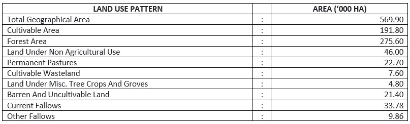
Land Use & Cropping PatternThe district has 569901 ha of geographical area of which roughly half (48.4 per cent) is covered with forest. Permanent pastures accounts for 4 per cent of the geographical area (Table 2). Area under current fallow and other fallow adds to 0.59 lakh ha sharing 9 per cent of the geographical area of the district. The net area sown is 1.61 lakh ha accounting for little more than a quarter (28.33 per cent) of the geographical area. The cropping intensity is 124.5 per cent indicating 24 per cent of the net sown area (153400 ha) is cropped more than once.
There are 2,16,486 number of holdings in the district operating 2,03,198 ha of land. The small and marginal holdings dominate the number and accounts for more than 89 per cent of the holdings in the district. However, the small and marginal farmers together operate 65 per cent of the total operated area.
Total area irrigated in the district from all sources adds up to 71805 ha. Canal irrigation covers 10935 ha, accounting for 15.23 per cent of the total irrigated area in the district. Canal water is available in all the taluks of the district except Gundulpete taluk. Tubewells are the major source of irrigation in the district and contribute 79.8 per cent to the irrigated area.
Sources Of Irrigation Of Chamarajanagara District

Due to erratic rainfall, high surface run-off owing to undulating terrain and granite hills with poor percolation of rain water into the soil and also increasing ground water draft, the water table has been depleted in the last decade resulting in Kollegala taluk becoming Dark and Chamarajanagara Taluk Grey. The open wells, which once served as a major source of irrigation have either turned dry or have water only during monsoon months. As the state of development of ground water varied between 47 and 66% of net utilisable recharge, there exists scope for further installation of water lifting devices such as electrical or diesel pumpsets and minor irrigation structures such as dug wells and tube wells in three taluks viz., Gundlupete, Yalanduru and Chamarajanagara.
As per the latest ground water assessment data available from the Department of Mines and Geology (Ground Water), Gundlupete and Yalanduru are categorised as White, Chamarajanagara as Grey, and Kollegala as Dark. Therefore, there is scope for further exploitation of ground water in the district, particularly in the taluks of Gundlupeta and Yalanduru and to some extent in Chamarajanagara.
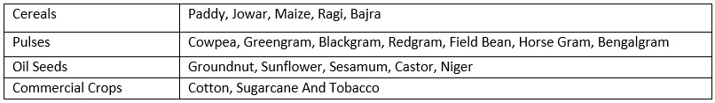
Cropping Pattern & Type of Field Crops Grown In The Area AgricultureChamarajanagara district depends mainly on monsoon for agricultural operations. Around 41 per cent of the net sown area is under cereals and 31 per cent under pulses. Thus food grain crops cover almost three fourth (71 per cent) of the net sown area. 78 % of the area under cereals is occupied by Jowar and maize and rest is shared occupied by paddy, ragi and bajra. Among pulses, horse gram accounts for 76 % of the pulses area. Groundnut, sunflower and sesame are important oilseed crops of the district. Cotton and sugarcane are the major commercial crops grown in the district.
There are two main crop seasons in the district i.e., Kharif and Rabi. Kharif is the predominant season which is divided into early kharif and late kharif. It extends from April to September. During early Kharif Jowar, Cotton and sunflower are taken up between first weeks of April and May in Gundlupete and Chamarajanagara taluks. Regular kharif crops are Paddy, Maize, Bajra, Pulses and Groundnut. Rabi sowing of Jowar, Horse gram, Bengal gram and Sunflower is from second fortnight of September to October end. Sugarcane is planted throughout the year.
Type of Horticultural Crops In The AreaHorticulture is a major allied agricultural activity in the district. Fruits are grown over an area of 22,453 ha, while vegetables occupy an area of 12,985 ha. Major fruits are banana, mango, sapota, papaya and pomegranate. Major vegetables grown are tomato, beans, brinjal, bhendi, green chilies and leafy vegetables. Plantation crops, mainly coconut is grown in an area of about 12,569 ha. Flowers, ornamentals, aromatic and medicinal plants are also cultivated in the district.
SericultureChamarajanagara district is known for its Silk. Sericulture gives steady income to the farmers. Mulberry is cultivated on an area of 1321 ha with a cocoon production of 296 tonnes. About 2136 farmers are involved in this activity.
Animal HusbandryAnimal Husbandry is another complimentary activity in the district. The animal population of the district comprises 2,49,361 cattle, 9918 buffaloes, 1,35,321 sheep, 1,44,633 goats, and 7,26,104 poultry birds. There is good scope for Inland Fisheries in the district. Since the district lacks coast lines, fishing activity is confined to inland fishing. Fisheries are mostly carried out in major tanks and reservoir areas of river Cauvery and its tributaries. Chamarajanagara district is endowed with more than 8000 hectares of inland water resources comprising of reservoirs, tanks and river stretch.
Social ForestryThe district has a total forest area of 2,75,610 ha (48 per cent of geographical area). Social forestry scheme is meant for creation of block plantation, canal bank plantations, tree planting in institutions like temples, schools, grave yards, government offices, tank foreshore areas, bunds of agriculture land, avenue plantation. This will provide employment, fire wood, small timber, fodder and green manure requirements of the people. This will also reduce the load on natural forests being indiscriminately cut. Rural Industries
Chamarajanagara is industrially backward district. However, there is ample scope to set up agro based industries for processing of horticultural crops in the district. But there is lack of entrepreneurship among people in the district. At present, there are 7 agro-based, 10 textile based and equal number of wood based and 70 other industries registered under SSI.
Natural Resources EndowmentsChamarajanagara district is rich in natural resources. The District has 4 A E which is rich in flora and fauna. B.R.Hills, M.M.Hills, Bharachukki Falls, Gopalaswamy Hills, Bandipura National Park are tourist centres attracting tourists in the district. The district has bimodel rainfall pattern best suited to grow short/ medium duration crops and for adopting mixed and inter cropping. Kabini and Gundal Project, Suvarnavathi and Chikkahole reservoirs provide scope for growing irrigated crops.
Important Development Indicators Some of the important development indicators of Chamarajanagra district are as below. 1. Gross Domestic Product (GDP) – Rs. 2,969 Crores contributing 1.0% to state GSDP (2012) 2. The Per Capita Annual Income Of The District - Rs. 1,39, 006 (2018-2019) 3. Birth & Death Rates – 11.5 and 10.1 Respectively (2017) 4. Sex Ratio – 993 Female Per 1000 Male (2009-2010) 5. The Human Development Index (HDI)- 21st Rank (0.601) 6. Infant Mortality Rate – 22.98/1000 live births (2009-2010) 7. Literacy Rate - 61.43 per cent